Weather Bee: North India saw twice the rain of their wettest normal last week
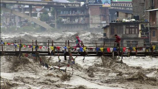
Weather Bee: A death toll in the dozens, floodwater gushing through highways, and strain on the reservoir capacity of dams make it clear that the past week was unusually rainy in India’s northern states and Union Territories (UTs).
How unusual was this rain? An HT analysis of India Meteorological Department’s (IMD) gridded dataset shows that the past week was around twice as rainy as the rainiest week on the long period average (LPA) chart of India’s most northern regions, although there are differences across states.
Himachal Pradesh, Uttarakhand, Punjab, and the UT of Jammu and Kashmir have been the worst affected by rain-related disasters in the past week. Therefore, HT checked how unusual the rain was in the week. The conventional way of checking this is by ranking rain across years. This confirms that rain in the four regions was far from usual last week. Rain in the week ending August 29 is ranked the highest for the week since 1901 (earliest available data) in Himachal Pradesh and Punjab, and the seventh and eighth highest in Jammu and Kashmir and Uttarakhand.
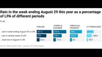
Another conventional way of checking rain’s unusual (or usual) nature is by comparing rain in a period one is studying with the average for the same period in the past (called the LPA). IMD currently uses the 1971-2020 average as the LPA for such comparisons. This also shows that the rain in the past week is a big departure from the past. The rain in the week ending August 29 this year is 2-4 times the LPA for the week in the four states and UTs.
Clearly, rain in the past week was unusual for this time of the year in India’s northern regions. However, a big departure from the past is also possible without an exceptional amount of rain in absolute terms. This is because conventional methods only compare the weather of a period with the past climate of the same period. If the past climate of a period is dry, a big departure is possible even with relatively less rain in absolute terms. For example, the week ending August 29 is not the rainiest week of the year in any of the four regions. The rainiest week of the year on the LPA chart is the week ending August 7 in Jammu and Kashmir and Punjab, and the weeks ending August 14 and August 19 in Himachal Pradesh and Uttarakhand.
Weather Bee: The rainiest week on the LPA chart highlights the peak of the monsoon season in the four regions, after which the season’s intensity is expected to decrease usually. However, that has not happened this year. The week ending August 29 was 1.5 times as rainy as the rainiest week on the LPA chart for Uttarakhand. This ratio was 2.3 for Himachal Pradesh, 2.5 times for Jammu and Kashmir, and 2.8 times for Punjab. This highlights just how unusual the past week’s rain was in even absolute terms in these regions.
There is another statistic that highlights just how unusually wet India’s northern regions were in the past week. Three of the regions received more than half a month’s worth of rain in the past week. Rain in Uttarakhand in the week was 39% of the LPA for August taken in its entirety. In Himachal Pradesh, Jammu and Kashmir, and Punjab, this share was 62%, 72%, and 82%.
 Weather Bee: In sum, these statistics highlight that India’s northern states have crumbled in the past week because they received an amount of rain that they are not used to receiving in any week of the year. However, this must not be taken to mean that the disasters that took place were unavoidable. At least the loss of lives could be decreased with early and effective communication of forecasts. It could also be decreased long-term if infrastructure is built keeping future projections of rain in mind. As HT regularly reports, both these preventive measures are lacking in most places where disasters strike.